
This loop walk is approximately 5 miles, but closer to 6 if you take the odd side detour, and I would allow around 3 hours. Expect to see spectacular coastal scenery, numerous historic sites, plenty of wildlife, and if hiking during a weekday, very few people.
 |
| St Aldhelm's head loop |
I opted to hike the loop in a anti-clockwise direction, I think because I had anticipated spending a little time exploring Winspit Quarry, which is towards the end of the loop if hiked this way around. One thing to note too is that the wind was much stronger north of St Aldhelm's head, and much calmer by Winspit, so it was nice to get that out of the way early on (that of course may not always be the case).
The hike starts at Worth Matravers village car park, which has plenty of spaces, but I would think fills up on busier days by lunchtime (especially with the pub close by). From the car park walk south past the pub, and veer right towards the village Pond, this makes a a nice first photo stop.
 |
| Worth Matravers Duck Pond |
From the Duck Pond you can either take the road on the north side or south side, both lead to Weston Road that heads west out of the village. Walk along the road for approximately 0.4 mile until you pass Weston Farm, then after the barns on the left is a track with a footpath sign, then after a few paces more a gate on the right leading into the fields. Take the footpath across the field in a westerly direction until you reach Renscombe car park. The Renscombe common was home to a World War 2 Radar research facility, but more on that later.
Take the footpath at the south end of the car park southwesterly across the farm fields to a stile, here you will catch your first glimpse of Chapman's Pool, and connect with the South West Coast Path.
 |
| Chapman's Pool & Portland Bill |
Once over the stile and on the South West Coast Path, head south with Chapman's Pool on your right (if you are feeling energetic you can make the out and back to the bay). If you look at the stone wall on your left, you will spot some inspiring words installed in the wall, and will soon reach the Royal Marines memorial.
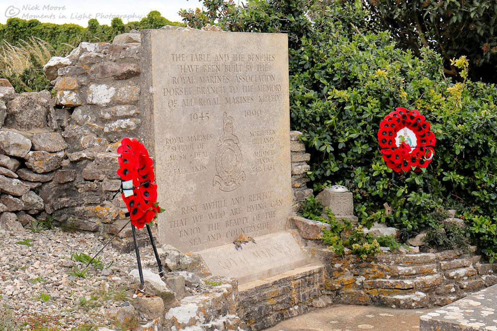 |
| Royal Marines memorial |
After passing the memorial and climbing another stile, you will be rewarded with some cracking views back to Chapman's Pool, and if lucky less of a sea breeze than we encountered.
 |
| Chapman's Pool |
Moving along with Chapman's Pool over your right shoulder you reach Emmetts Hill, it is here where the steepest part of the hike is encountered, a quick steep descent down numerous steps, followed by a longer steeper ascent (not recommended for anyone with a fear of heights or for people who can not manage steep steps!).
 |
| Emmetts Hill |
After panting your way up the hill, you shortly arrive at St Aldhelm's head, which makes a nice rest and selfie stop. The unique square chapel dates from the 12th century, taking its name from the first bishop of Sherborne.
 |
| St Aldhelm's Chapel |
 |
| St Aldhelm's Chapel |
The coastguard station is a "little" newer, built in the 1970's, and is manned by the National Coastwatch. Originally the station was at Chapman's Pool, but it was deemed to be too isolated so was moved. If you peer over the cliffs, but do not get too close, you can see evidence of past stone quarrying, a common sight along this coastline.
 |
| St Alban's Head Coastguard station |
From the coastguard station head easterly on the South West Coast Path to the Radar monument. The monument is here to commemorate the research into Radar technology carried out at nearby RAF Worth Matravers during World War 2, I found it to be quite photogenic.
 |
| Radar monument & St Aldhelm's Chapel |
 |
| Radar monument & Coastguard station |
From the Radar monument the Coast Path heads easterly gradually descending to Winspit and sea level. The views and cliffs are spectacular along this section, keep your eye out for the many birds that call this area home - including Gulls, Cormorants, and Peregrine Falcons. You will come across 1 or 2 strategically placed benches en-route, that make a great picnic spot with a view.
Approximately 1.2 miles from St Aldhelm's head you reach Winspit Quarry, this impressive 18th century mining operation has left caves and shelves jutting out to sea. Portland stone was quarried here up until the 1950's, and the stone used in many famous public buildings in London and beyond. The caves today are home to bats, and it is best advised to not disturb them and view the caves from outside.
 |
| Winspit quarry |
 |
| The rock shelves left from quarrying |
 |
| Coastal plants seemed to like the sheltered quarry |
Winspit quarry makes an ideal picnic spot, it is fairly well sheltered and has some great views, but is not suitable for swimming. The cliffs along this stretch of coastline are popular with rock climbers, and we saw quite a few hiking with ropes.
At Winspit our walk leaves the coast behind and heads north, Worth Matravers is only 1.2 miles away now. This final stretch follows a track that steadily gains altitude, you will reach a fork in the track at what appears to be a water treatment plant, follow the footpath here that veers from the track through a tunnel of blackberry bushes and into a field.
 |
| Worth Matravers approaching from Winspit |
The footpath takes you through a gate in between houses, and pops you out right by the village pond where you started. The car park is back up the road past the pond, but if you timed your walk right, be sure to stop at the The Square and Compass Pub. We stopped by the pub right after they re-opened from Covid-19 closure, so social distancing was in force, but luckily the pub has plenty of outdoor space, and of course cracking sea views.
Essential information
No comments:
Post a Comment